PILOT TOOL - NOT PLANNING, LEGAL OR ENGINEERING ADVICE. Screening only, from open NSW government data at the time shown. Confirm with a s10.7 planning certificate, the council, and a registered certifier before quoting or lodging. Flood is not assessed from state data for these councils. Costs are indicative only, not a quote, AUD inc GST (base rate A$2,200/m² inc GST + 17% loading for margin and contingency = A$2,574/m²; other lines estimates inc GST or PLACEHOLDER). Floor plans are concept only. Indicative only, not a quote or tender. Excludes site-specific conditions, authority fees beyond the rough lines shown, variations and price escalation. Not design, planning or certification advice. Get a formal quote and site inspection from a licensed builder before deciding.
OK on open data: Zone is a residential zone (Housing SEPP applies); Lot area at least 450 m² (CDC); Frontage at building line at least 12 m (CDC); Bush fire prone land; Heritage item (LEP); State Heritage Register; Mine subsidence; Dual occupancy permissible; Low and Mid Rise housing area; Zone allows Low Rise Housing Diversity Code CDC; Lot width at building line at least 15 m (CDC); Codes SEPP Schedule 5 local exclusion map.
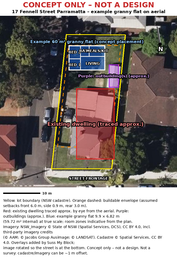
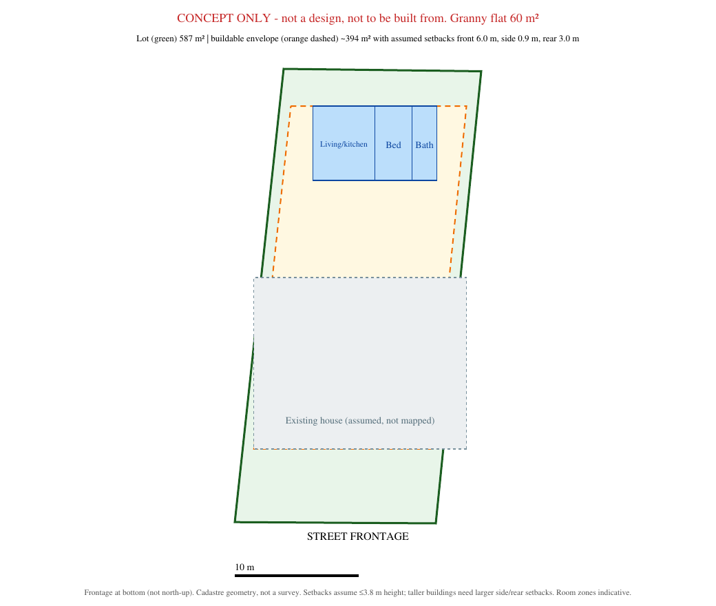
Design limits (CDC): Housing SEPP: 60 m², or larger if another EPI permits. LEP cl 5.4(9): greater of 60 m² or 5% of principal dwelling floor area. Whether a certifier accepts the LEP % as 'permitted under another EPI' for a CDC is an interpretation question (AI-checked 11 Oct 2026: not settled by the text; not certifier-verified) - confirm with a certifier. Total floor area (house + granny flat + enclosed attached structures) max 330 m²; site coverage max 50% (= 295 m²); landscaped area min 20% (= 118 m²), half behind the building line; height max 8.5 m (Sch 1 s 6). Setbacks for a building up to 3.8 m high: side min 0.9 m (Sch 1 s 9), rear min 3 m (Sch 1 s 10); above 3.8 m add 25% of the extra height to the side setback and 3 x the extra height to the rear (rear capped at 8 m). Principal private open space more than 24 m², more than 4 m wide, off a living room, no steeper than 1:50 (Sch 1 s 17). Check against the existing house on site.
| Data point | Value | Source | Data date | Note |
|---|---|---|---|---|
| Address (matched) | 17 FENNELL STREET PARRAMATTA | NSW Geocoded Addressing Theme - AddressPoint | 2008-04-18 | |
| Lot(s) | 1//DP69389 | NSW Land Parcel Property Theme - Lot | 2004-11-26 | |
| Council (LGA) | PARRAMATTA | NSW Administrative Boundaries Theme - LocalGovernmentArea | 2026-08-04 | Spatial Services LGA name: CITY OF PARRAMATTA |
| Zone | R2 | EPI Primary Planning Layers - Land Zoning | 2026-08-07 | Parramatta Local Environmental Plan 2023; Low Density Residential; commenced 2024-07-01; all zones on site: R2 |
| Site area | 590 m² (approx.) | NSW Land Parcel Property Theme - Property | 2026-10-16 (fetched) | Geodesic area of the cadastral polygon (GRS80); no usable plan area for this property. Not a survey; title/plan area governs. |
| Road frontage | 16.4 m to Fennell Street (estimate); corner lot (Trott Street 37.0 m, Fennell Street 16.4 m) | Derived: site boundary coinciding with NSW RoadCorridor polygons (±0.1 m) | ESTIMATE ONLY. Measured along the boundary, not at the building line. Primary road FENNELL STREET (from the address); all road contact: TROTT STREET 37.0 m, FENNELL STREET 16.4 m; looks like a CORNER lot | |
| Lot shape | Standard (no access handle found) | Derived: battle-axe detection from cadastral polygon vs NSW RoadCorridor polygons (cadastre opening r=4.0 m vs RoadCorridor (+/-1.5 m)) | 2004-11-26 | ESTIMATE from the cadastre. Access handle width is an average (handle area / length). Survey and title govern (including any right of carriageway). |
| FSR (LEP) | 0.5:1 | EPI Primary Planning Layers - Floor Space Ratio | 2026-09-04 | Clause 4.4; values on site: 0.5 |
| Max height (LEP) | 9.0 m | EPI Primary Planning Layers - Height of Building | 2026-08-07 | Clause 4.3; m; values on site: 9.0 |
| Min lot size (LEP subdivision) | 550 m² | EPI Primary Planning Layers - Lot Size | 2026-06-12 | Clause 4.1; m²; subdivision control |
| Result | Check | For | Finding | Clause and source text |
|---|---|---|---|---|
| NO | Heritage conservation area | GF+DO | Lot is in a heritage conservation area. Codes SEPP cl 1.19(1)(a) excludes new dwellings from complying development (only detached outbuildings/detached development/pools). Expect a DA. | Codes SEPP cl 1.19(1)(a) “land within a heritage conservation area or a draft heritage conservation area, unless the development is a detached outbuilding, detached development (other than a detached studio) or swimming pool” https://legislation.nsw.gov.au/view/whole/html/inforce/current/epi-2008-0572 (in force 2026-09-11) |
| NO | LEP dual occupancy minimum lot (600 m², 15 m frontage) | DO | Site 589.5 m² (FAIL); estimated frontage 16.4 m (PASS). | Parramatta LEP 2023 cl 4.1C(2) “Development for a purpose specified in the table to this subclause may be carried out on a lot in a zone specified opposite if— (a) the area of the lot is at least 600m2, and (b) the lot has at least a 15m wide frontage to a public road. [Dual occupancies: Zones R2, R3 and R4]” https://legislation.nsw.gov.au/view/whole/html/inforce/current/epi-2023-0117 (in force 2026-09-04) |
| NO | Dual Occupancy Prohibition Map vs complying development | DO | CDC not assumed on a Prohibition Map lot: whether the LRHD code CDC is available here is UNVERIFIED. Use a DA. | - |
| NO | Parent lot at least 600 m² (CDC) | DO | Site 589.5 m². Threshold is the greater of 400 m² and the LEP dual occupancy minimum (600 m²). | Codes SEPP cl 3B.8(1) “The area of the parent lot must not be less than whichever is the greater of the following— (a) 400m2, (b) the minimum lot area specified for dual occupancies in the environmental planning instrument, other than State Environmental Planning Policy (Housing) 2021, Chapter 6, Part 2, Division 2, that applies to the land concerned.” https://legislation.nsw.gov.au/view/whole/html/inforce/current/epi-2008-0572 (in force 2026-09-11) |
| CHECK | Dual Occupancy Prohibition Map (Parramatta LEP) | DO | Lot is on the Dual Occupancy Prohibition Map, but it is R2 land where Housing SEPP Chapter 6 permits dual occupancies with consent. City of Parramatta has approved DAs on map lots on that basis (e.g. DA/260/2026, public assessment report). Treat as a DA; confirm with council. (Public-document evidence, not certifier-verified.) | Parramatta LEP 2023 cl 6.11(1) “Development consent must not be granted to development for the purposes of dual occupancies on land identified as “D” on the Dual Occupancy Prohibition Map.” https://legislation.nsw.gov.au/view/whole/html/inforce/current/epi-2023-0117 (in force 2026-09-04) |
| CHECK | Detached dual occupancy restriction (Parramatta LEP) | DO | Detached dual occupancies are not allowed in residential zones unless the lot contains a heritage item, has 2 street frontages, is a corner lot, or is in the South Parramatta Conservation Area. Plan an ATTACHED dual occupancy unless an exception is confirmed. Cadastre suggests a CORNER lot (TROTT STREET, FENNELL STREET), so exception (c) may apply - confirm the corner-lot definition (Codes SEPP: 2 contiguous road boundaries meeting at 135 degrees or less) on survey. | Parramatta LEP 2023 cl 6.11(2) “Development consent must not be granted to development for the purposes of dual occupancies (detached) on land in a residential zone unless the land— (a) contains a heritage item, or (b) has 2 street frontages, or (c) is a corner lot within the meaning of State Environmental Planning Policy (Exempt and Complying Development Codes) 2008, or (d) is shown in red hatching and identified as “South Parramatta Conservation Area” on the Heritage Map.” https://legislation.nsw.gov.au/view/whole/html/inforce/current/epi-2023-0117 (in force 2026-09-04) |
| CHECK | Other LRHD exclusions to confirm | DO | Confirm: not a battle-axe lot, no existing secondary dwelling or group home on the lot, no building over a registered easement, sewered land, not landslide risk land. Data hints: lot shape check found no access handle (not a battle-axe lot on the cadastre). | Codes SEPP cl 3B.2(c), (d), (e), (i), (j) “(c) development on a battle-axe lot, (d) development on any lot on which there is a secondary dwelling or group home ..., (e) the erection of a building over a registered easement, ... (i) development on unsewered land, (j) development on land identified as susceptible to landslide risk in— (i) an environmental planning instrument applying to the land” https://legislation.nsw.gov.au/view/whole/html/inforce/current/epi-2008-0572 (in force 2026-09-11) |
| NO DATA | Flood | GF+DO | The state flood planning layers hold NO data for Ryde, Parramatta, Dubbo Regional or Maitland (councils own flood mapping since July 2021). Obtain the s10.7 planning certificate / council flood certificate to confirm whether this is a flood control lot. If it is, Housing SEPP s 58 and Codes SEPP cl 3B.5 standards apply. | Housing SEPP s 58(1) “Complying development under this Division must not be carried out on the following parts of a flood control lot ... (a) a flood storage area, (b) a floodway, (c) a flow path, (d) a high hazard area, (e) a high risk area.” https://legislation.nsw.gov.au/view/whole/html/inforce/current/epi-2021-0714 (in force 2026-09-11) |
| NO DATA | Interim heritage order | GF+DO | Current IHO list not available or more than 14 days old - run tools/fetch_iho.py, or check the s10.7 certificate. | Codes SEPP cl 1.17A(1)(d)(ii) “be carried out on land that— ... (ii) is subject to an interim heritage order under that Act or on which is located an item that is so subject” https://legislation.nsw.gov.au/view/whole/html/inforce/current/epi-2008-0572 (in force 2026-09-11) |
| NO DATA | Sewer connection | GF+DO | Check sewer connection. No reliable open sewer-network data is used. Water/sewer authority: Sydney Water. If unsewered, an on-site effluent system approval (LG Act s 68) is needed before a CDC, and Low Rise Housing Diversity Code CDC is not available (cl 3B.2(i)). | Codes SEPP cl 1.18(1)(d)(i) “before the complying development certificate is issued, have an approval, if required by the Local Government Act 1993, for— (i) an on-site effluent disposal system if the development is undertaken on unsewered land” https://legislation.nsw.gov.au/view/whole/html/inforce/current/epi-2008-0572 (in force 2026-09-11) |
| OK | Zone is a residential zone (Housing SEPP applies) | GF | Zone R2. Housing SEPP Part 1 applies where a dwelling house is permissible. Dwelling houses permitted in R2 under the LEP: yes. LEP land use table entry for secondary dwellings: not_listed_closed. | Housing SEPP s 49 (definition of residential zone), s 50 “This Part applies to development for the purposes of a secondary dwelling on land in a residential zone if development for the purposes of a dwelling house is permissible on the land under another environmental planning instrument.” https://legislation.nsw.gov.au/view/whole/html/inforce/current/epi-2021-0714 (in force 2026-09-11) |
| OK | Lot area at least 450 m² (CDC) | GF | Site area 589.5 m² (cadastre; not a survey). | Housing SEPP s 54(2)(c) “is on a lot with an area of at least 450m2” https://legislation.nsw.gov.au/view/whole/html/inforce/current/epi-2021-0714 (in force 2026-09-11) |
| OK | Frontage at building line at least 12 m (CDC) | GF | Estimated road frontage 16.4 m (derived from cadastre; not at the building line). | Housing SEPP Sch 1 s 2(1)(b) “has a boundary with a primary road, measured at the building line, of at least the following— (i) if the lot has an area of at least 450m2 but not more than 900m2—12m, (ii) ... more than 900m2 but not more than 1500m2—15m, (iii) ... more than 1500m2—18m” https://legislation.nsw.gov.au/view/whole/html/inforce/current/epi-2021-0714 (in force 2026-09-11) |
| OK | Bush fire prone land | GF+DO | No bush fire prone land mapped on any part of the lot (NSW RFS BFPL via Planning Portal). | Housing SEPP s 57(2) “Complying development under this Division must not be carried out on a lot that contains bush fire prone land unless— (a) the development conforms to the relevant specifications and requirements of Planning for Bush Fire Protection ...” https://legislation.nsw.gov.au/view/whole/html/inforce/current/epi-2021-0714 (in force 2026-09-11) |
| OK | Heritage item (LEP) | GF+DO | No LEP heritage item mapped on the lot. | Codes SEPP cl 1.17A(1)(d)(iii) “is identified as an item of environmental heritage or a heritage item by an environmental planning instrument or on which is located an item that is so identified” https://legislation.nsw.gov.au/view/whole/html/inforce/current/epi-2008-0572 (in force 2026-09-11) |
| OK | State Heritage Register | GF+DO | No State Heritage Register curtilage on the lot. | Codes SEPP cl 1.17A(1)(d)(i) “comprises an item that is listed on the State Heritage Register under the Heritage Act 1977 or on which such an item is located” https://legislation.nsw.gov.au/view/whole/html/inforce/current/epi-2008-0572 (in force 2026-09-11) |
| OK | Mine subsidence | GF+DO | Not in a mapped mine subsidence district. | Codes SEPP cl 1.18(1)(f) “if it is the alteration or erection of improvements on land in a mine subsidence district within the meaning of the Mine Subsidence Compensation Act 1961, have the prior approval of the Mine Subsidence Board” https://legislation.nsw.gov.au/view/whole/html/inforce/current/epi-2008-0572 (in force 2026-09-11) |
| OK | Dual occupancy permissible | DO | Zone R2: dual occupancies permitted with consent under the LEP land use table (listed). | Parramatta LEP 2023 Part 2 Land Use Table (zone permissibility) https://legislation.nsw.gov.au/view/whole/html/inforce/current/epi-2023-0117 (in force 2026-09-04) |
| OK | Low and Mid Rise housing area | DO | Not in a Low and Mid Rise housing area: no Town Centre within 800 m and no Schedule 11 station public entrance within 800 m straight-line of the lot (walking distance is never shorter). Entrances: TfNSW Train Station Entrances 2020 (CC BY 3.0 AU); entrances built after 2020 are not in that data. LEP standards govern. | Housing SEPP s 163 (definition of low and mid rise housing area) “land within 800m walking distance of— (i) land identified as “Town Centre” on the Town Centres Map, or (ii) a public entrance to a railway, metro or light rail station listed in Schedule 11” https://legislation.nsw.gov.au/view/whole/html/inforce/current/epi-2021-0714 (in force 2026-09-11) |
| OK | Zone allows Low Rise Housing Diversity Code CDC | DO | Zone R2. | Codes SEPP cl 3B.1(3)(a) “the lot must be in Zone RU5, Zone R1, Zone R2 or Zone R3” https://legislation.nsw.gov.au/view/whole/html/inforce/current/epi-2008-0572 (in force 2026-09-11) |
| OK | Lot width at building line at least 15 m (CDC) | DO | Estimated frontage 16.4 m (cadastre-derived, not at the building line). | Codes SEPP cl 3B.8(2) “The width of the parent lot must not be less than the following when measured at the building line— (a) if the car parking space for the parent lot is accessed only from a secondary road, parallel road or lane—12m, (b) otherwise—15m.” https://legislation.nsw.gov.au/view/whole/html/inforce/current/epi-2008-0572 (in force 2026-09-11) |
| OK | Codes SEPP Schedule 5 local exclusion map | DO | Not on a mapped Schedule 5 local exclusion. | Codes SEPP cl 1.19(2) “Development specified in the Housing Code, the Inland Code, the Low Rise Housing Diversity Code or the Pattern Book Development Code is not complying development under that code if it is carried out on land described or otherwise identified on a map specified in Schedule 5.” https://legislation.nsw.gov.au/view/whole/html/inforce/current/epi-2008-0572 (in force 2026-09-11) |
| NOTE | Maximum granny flat floor area | GF | Housing SEPP: 60 m², or larger if another EPI permits. LEP cl 5.4(9): greater of 60 m² or 5% of principal dwelling floor area. Whether a certifier accepts the LEP % as 'permitted under another EPI' for a CDC is an interpretation question (AI-checked 11 Oct 2026: not settled by the text; not certifier-verified) - confirm with a certifier. | Housing SEPP Sch 1 s 4(1); s 52(2)(c); LEP cl 5.4(9) “The floor area of a secondary dwelling, excluding an attached ancillary structure, must not be more than— (a) 60m2, or (b) if a larger floor area is permitted for a secondary dwelling on the land under another environmental planning instrument—the larger floor area.” https://legislation.nsw.gov.au/view/whole/html/inforce/current/epi-2021-0714 (in force 2026-09-11) |
| NOTE | Design limits for this lot size (CDC) | GF | Total floor area (house + granny flat + enclosed attached structures) max 330 m²; site coverage max 50% (= 295 m²); landscaped area min 20% (= 118 m²), half behind the building line; height max 8.5 m (Sch 1 s 6). Setbacks for a building up to 3.8 m high: side min 0.9 m (Sch 1 s 9), rear min 3 m (Sch 1 s 10); above 3.8 m add 25% of the extra height to the side setback and 3 x the extra height to the rear (rear capped at 8 m). Principal private open space more than 24 m², more than 4 m wide, off a living room, no steeper than 1:50 (Sch 1 s 17). Check against the existing house on site. | Housing SEPP Sch 1 s 4(2) “(a) if the lot has an area of at least 450m2 but not more than 600m2—330m2, (b) ... more than 600m2 but not more than 900m2—380m2, (c) ... more than 900m2—430m2.” https://legislation.nsw.gov.au/view/whole/html/inforce/current/epi-2021-0714 (in force 2026-09-11) |
| NOTE | No subdivision | GF | A lot with a Housing SEPP granny flat cannot be subdivided. | Housing SEPP s 51 “Development consent must not be granted for the subdivision of a lot on which development has been carried out under this Part.” https://legislation.nsw.gov.au/view/whole/html/inforce/current/epi-2021-0714 (in force 2026-09-11) |
| NOTE | Acid sulfate soils | GF+DO | Acid sulfate soils Class 5 mapped: not a CDC exclusion, but earthworks limits apply (Housing SEPP Sch 1 s 18). | Codes SEPP cl 1.19(1)(c) “land identified on an Acid Sulfate Soils Map as being Class 1 or Class 2” https://legislation.nsw.gov.au/view/whole/html/inforce/current/epi-2008-0572 (in force 2026-09-11) |
| NOTE | Council note | GF+DO | Parramatta LEP 2023 Land Use Table does not name secondary dwellings in R2-R4; they are permitted with consent via Housing SEPP s 50 and s 52. | - |
| NOTE | Easements | GF+DO | No easement polygon mapped in the cadastre. Not all easements are mapped (e.g. many sewer easements): a title search is still needed. | - |
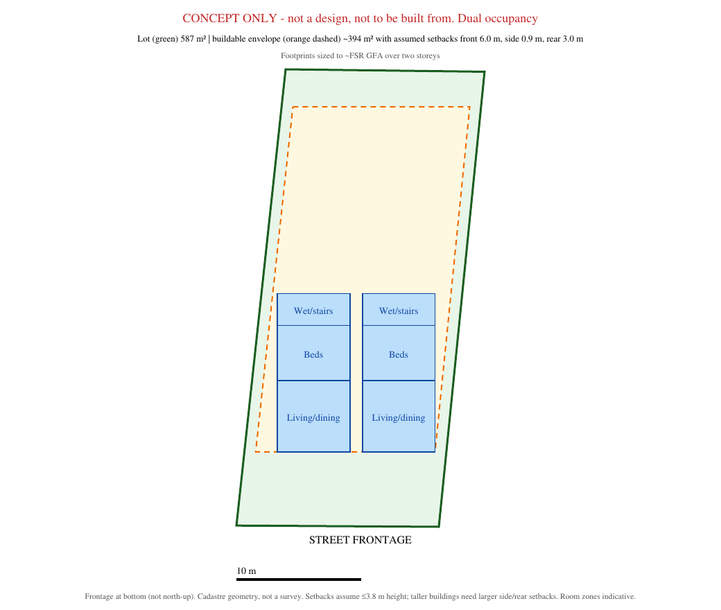
| NOTE | Design limits (CDC) | DO | Max GFA of all buildings 447 m²; max height 8.5 m. | Codes SEPP cl 3B.9, cl 3B.10 “The maximum height for a dual occupancy and any attached development is 8.5m above ground level (existing). ... Lot area of parent lot 400m2–2,000m2: 25% of lot area + 300m2; >2,000m2: 800m2” https://legislation.nsw.gov.au/view/whole/html/inforce/current/epi-2008-0572 (in force 2026-09-11) |
| NOTE | LEP FSR and height (DA) | DO | Mapped FSR 0.5; mapped max height 9.0 m. | Parramatta LEP 2023 cl 4.4 (Floor space ratio) https://legislation.nsw.gov.au/view/whole/html/inforce/current/epi-2023-0117 (in force 2026-09-04) |
Base rate A$2,200/m² inc GST plus a single 17% loading covering builder margin and contingency combined (effectively A$2,574/m² inc GST).
PLACEHOLDER RATES from config/costs.yaml - not market figures, not a quote.
| Item | Amount inc GST | Rate source |
|---|---|---|
| Base build 60 m² × $2,200/m² | $132,000 | costs_bobby.yaml build_rates_per_m2.secondary_dwelling_detached |
| Base site allowance | $10,000 PLACEHOLDER | costs_bobby.yaml site_costs.base_site_allowance |
| SITE COST - reactive clay allowance (separate from base rate): class UNKNOWN (No geotech yet - allowance assumes H1 until a report is obtained) 60 m² slab × $40/m² (Site class needs a geotechnical report (AS 2870).) | $2,400 PLACEHOLDER | costs_bobby.yaml site_costs.soil_class_extra_per_m2_slab.UNKNOWN |
| Constraint allowance: sewer unknown contingency (until sewer connection confirmed) | $5,000 PLACEHOLDER | costs_bobby.yaml constraint_allowances.sewer_unknown_contingency |
| Constraint allowance: heritage da consultant | $5,000 PLACEHOLDER | costs_bobby.yaml constraint_allowances.heritage_da_consultant |
| DA fees and reports | $10,000 PLACEHOLDER | costs_bobby.yaml authority_and_fees.da_fees_and_reports |
| BASIX NATHERS | $1,000 PLACEHOLDER | costs_bobby.yaml authority_and_fees.basix_nathers |
| Survey | $2,000 PLACEHOLDER | costs_bobby.yaml authority_and_fees.survey |
| Geotech report | $1,000 PLACEHOLDER | costs_bobby.yaml authority_and_fees.geotech_report |
| Water/sewer authority fees (Sydney Water) | $1,000 PLACEHOLDER | costs_bobby.yaml authority_and_fees.water_sewer_authority_fees |
| Developer contributions (not calculated) (s7.11/s7.12 - check the council contributions plan; not calculated) | $0 PLACEHOLDER | costs_bobby.yaml authority_and_fees.developer_contributions |
| Subtotal | $169,400 | |
| Loading 17% on base build (builder margin + contingency combined) | $22,440 | |
| Total inc GST | $191,840 | |
| of which GST (1/11) | $17,440 |
| Scenario | GFA basis | Build: A$2,200/m² + 17% loading (range) | Extra cost lines (estimates) | Indicative total range |
|---|---|---|---|---|
| Granny flat (secondary dwelling) 60 m² (DA) | 60 m² - Housing SEPP 60 m² maximum (LEP may allow more; not assumed) | $154,400 ($139,000-$177,600) | DA lodgement fees + consultant reports (DA pathway): $8,800-$27,500 Design / drafting, BASIX, survey, geotech: $6,600-$19,800 Site works: excavation, retaining, drainage, driveway, services connections: $16,500-$66,000 |
$171,000 - $291,000 |
| Dual occupancy - 2 dwellings sharing FSR 0.5:1 (DA) | 295 m² - LEP FSR 0.5:1 × site area 590 m² = 295 m² GFA (whole site, both dwellings) | $759,300 ($683,400-$873,200) | DA lodgement fees + consultant reports (DA pathway): $8,800-$41,250 Design / drafting, BASIX, survey, geotech: $13,200-$39,600 Site works: excavation, retaining, drainage, driveway, services connections: $33,000-$132,000 Demolition of existing structures (only if needed): $16,500-$49,500 |
$755,000 - $1,136,000 |
| New dwelling house at full FSR (DA) | 295 m² - LEP FSR 0.5:1 × site area 590 m² | $759,300 ($683,400-$873,200) | DA lodgement fees + consultant reports (DA pathway): $8,800-$27,500 Design / drafting, BASIX, survey, geotech: $6,600-$19,800 Site works: excavation, retaining, drainage, driveway, services connections: $16,500-$66,000 Demolition of existing structures (only if needed): $16,500-$49,500 |
$732,000 - $1,036,000 |
Base rate A$2,200/m² inc GST plus a single 17% loading covering builder margin and contingency combined (effectively A$2,574/m² inc GST).
Assumptions: Base rate A$2,200/m² inc GST plus a single 17% loading covering builder margin and contingency combined (effectively A$2,574/m² inc GST). Build column = GFA × A$2,200/m² × 1.17 (17% loading = margin + contingency), range 90%-115%. Base build rate A$2,200/m² (Bobby, 11 Oct 2026), includes GST (Bobby confirmed 15 Oct 2026); range 90%-114% of rate. GFA from LEP FSR × cadastre site area (not a survey); actual GFA is limited by setbacks, height, site coverage, landscaping and the existing house. Extra lines are broad screening estimates, not quotes, shown inc GST (our ex-GST estimates + 10%); developer contributions (s7.11/s7.12), water authority fees and constraint allowances are not included in this range (see cost lines). Demolition assumed only for house / dual occupancy (existing house removed); granny flat assumes the house stays.
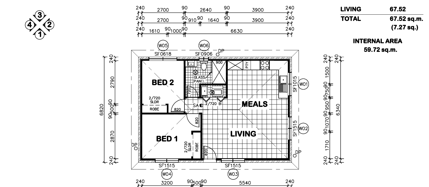
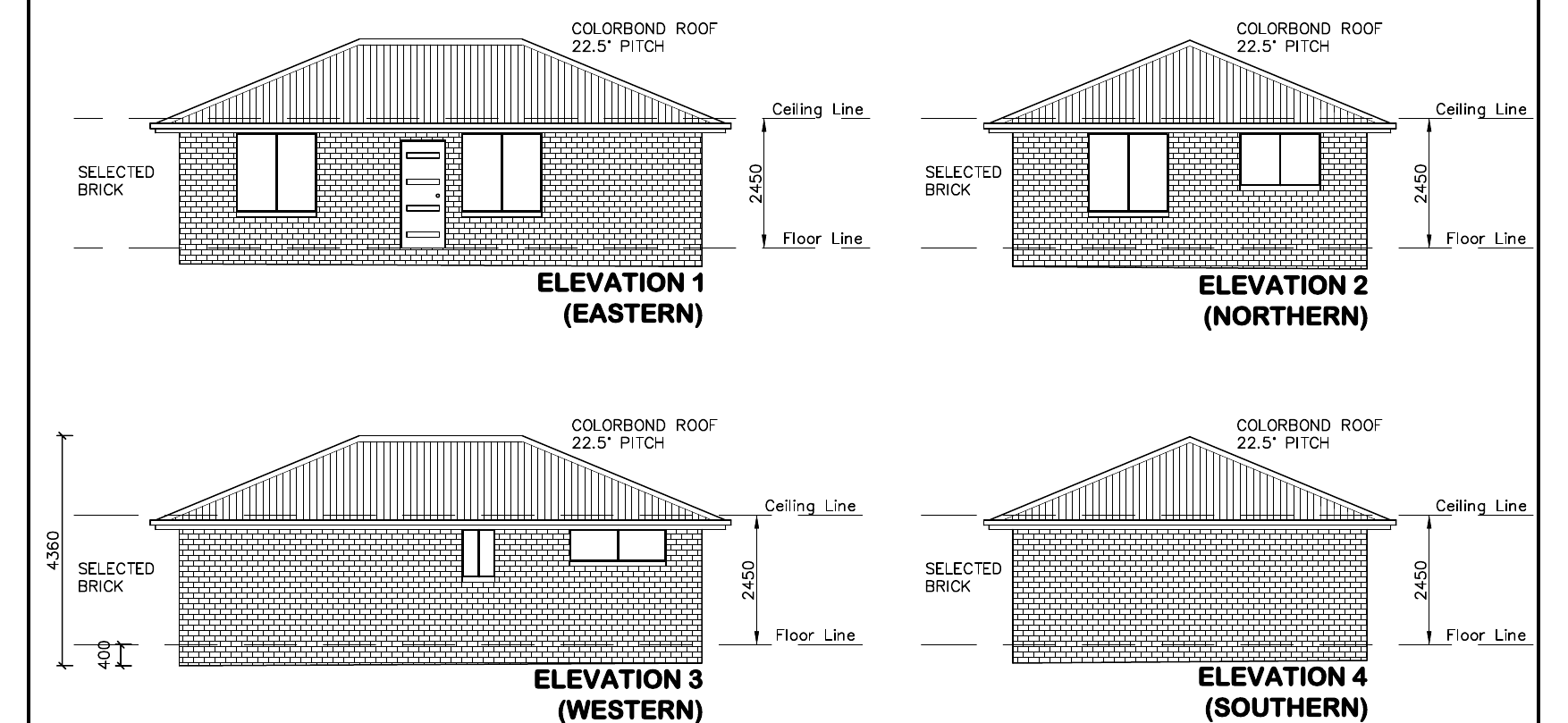
Internal area 59.72 m² (67.52 m² measured over external walls); 2 bedrooms, living/meals, kitchen, bathroom. Personal details removed.
CONCEPT / TEMPLATE ONLY - costs are rough estimates (AUD inc GST)
Likely pathway only, from open data. A registered certifier (CDC) or the council (DA) decides. Get the s10.7 planning certificate first - it can change the answer.
Dual occupancy: DA LIKELY (CDC blocked) - CDC blocked by: LEP dual occupancy minimum lot (600 m², 15 m frontage); Dual Occupancy Prohibition Map vs complying development; Parent lot at least 600 m² (CDC); Heritage conservation area
Timeframes: Prepare 4-10 weeks (typical). Council may reject if incomplete within 14 days (Reg s 39). Notification per council Community Participation Plan (~14 days). Assessment period 40 days before deemed refusal (60 if integrated/concurrence); NSW average ~70 days. Then a construction certificate (typically 2-6 weeks).
| ☐ | DA submission checklist | Who prepares | Rough cost (est., inc GST) |
|---|---|---|---|
| ☐ | Planning Portal DA form + owner's consent | Applicant/owner | - |
| ☐ | Cost estimate report | Builder/applicant (QS if >= A$3m) | A$0-1.5k |
| ☐ | Statement of Environmental Effects (SoEE) | Town planner or designer | A$1.5k-5k |
| ☐ | Detail + identification survey | Registered surveyor | A$1.5k-3.5k |
| ☐ | Site analysis plan | Designer | incl. in design |
| ☐ | Site, floor, elevation, section and roof plans | Building designer/architect | A$3k-9k (granny flat); A$8k-25k (dual occ) |
| ☐ | Shadow diagrams 21 June 9am/12pm/3pm | Designer | A$500-1.5k |
| ☐ | Landscape plan | Designer / landscape architect | A$500-2.5k |
| ☐ | Stormwater concept plan (OSD if required) | Hydraulic/civil engineer | A$1k-3.5k |
| ☐ | BASIX certificate (+ NatHERS) | Applicant / NatHERS assessor | A$150-600 / A$500-1.5k |
| ☐ | Waste management plan (demolition, construction, ongoing) | Applicant/designer | A$0-500 |
| ☐ | Erosion and sediment control plan | Designer/engineer | incl. |
| ☐ | A4 notification plan | Designer | incl. |
| ☐ | Council DA fee + notification + Planning Reform Fee | Council | A$1k-3.5k (est.) |
| ☐ | Construction certificate after consent | Council or registered certifier | A$3k-8k incl. inspections |
| ☐ | Heritage impact statement [triggered: heritage] | Heritage consultant | A$2k-6k |
| ☐ | Acid sulfate soils assessment / management plan [triggered: acid_sulfate] | Environmental consultant | A$1.5k-5k |
| ☐ | Geotechnical report (site class AS 2870) [triggered: site class unknown] | Geotechnical engineer | A$1k-2.5k |
Sources: NSW Planning Portal - local development (DA): https://www.planningportal.nsw.gov.au/onlineDA | planning.nsw.gov.au - complying development: https://www.planning.nsw.gov.au/the-planning-system/development-assessment/planning-approval-pathways/complying-development | DPHI Application requirements (approved form): https://www.planning.nsw.gov.au/sites/default/files/2023-02/application-requirements.pdf | EP&A Regulation 2021: https://legislation.nsw.gov.au/view/html/inforce/current/sl-2021-0759 | Codes SEPP 2008: https://legislation.nsw.gov.au/view/html/inforce/current/epi-2008-0572 ; Housing SEPP 2021: https://legislation.nsw.gov.au/view/html/inforce/current/epi-2021-0714
Nearby precedents within 1000 m (NSW Planning Portal DA/CDC data, extract 2026-09-30 08:20 AEST): granny flat CDC 3 (3 approved/determined), DA 7 (3 approved/determined); dual occ CDC 0 (0 approved/determined), DA 1 (1 approved/determined). Context only, not a pass/fail input.
Source: NSW Planning Portal Online DA Data API / Online CDC Data API (https://api.apps1.nsw.gov.au/eplanning/data/v0/); Creative Commons Attribution (per Planning Portal open data catalogue); extract 2026-09-30 08:20 AEST. Pilot-internal learning/ML and evidence only. Not to be resold or packaged as a data product.
| Application | Type | Status | Development | Address | Distance | Lodged |
|---|---|---|---|---|---|---|
| PAN-580592 | DA | Withdrawn | Secondary dwelling, Erection of a new structure, Residential Accommodation | 544 CHURCH STREET NORTH PARRAMATTA 2151 | 722 m | |
| PAN-583517 | DA | Rejected | Secondary dwelling, Erection of a new structure, Residential Accommodation | 544 CHURCH STREET NORTH PARRAMATTA 2151 | 722 m | |
| PAN-590290 | DA | Determined | Secondary dwelling, Erection of a new structure, Residential Accommodation | 544 CHURCH STREET NORTH PARRAMATTA 2151 | 722 m | 2025-11-14 |
| PAN-580629 | DA | Rejected | Secondary dwelling, Erection of a new structure, Residential Accommodation | 546 CHURCH STREET NORTH PARRAMATTA 2151 | 731 m | |
| PAN-583527 | DA | Rejected | Secondary dwelling, Erection of a new structure, Residential Accommodation | 546 CHURCH STREET NORTH PARRAMATTA 2151 | 731 m | |
| PAN-590357 | DA | Determined | Secondary dwelling, Erection of a new structure, Residential Accommodation | 546 CHURCH STREET NORTH PARRAMATTA 2151 | 731 m | 2025-11-25 |
| Layer | Result on lot | Fetched (Sydney time) | Licence | URL |
|---|---|---|---|---|
| EPI Primary Planning Layers - Land Zoning | 1 feature(s): [{"AMENDMENT": "State Environmental Planning Policy Amendment (Church Street North Precinct) 2023", "COMMENCED_DATE": "2024-07-01", "CURRENCY_DATE": "2026-08-07", "EPI_NAME": "Parramatta Local Environmental Plan 2023", "LAY_CLASS": "Low Density Residential", "LEGIS_REF_CLAUSE": null, "LGA_NAME": "CITY OF PARRAMATTA", "SYM_CODE": "R2"}] | 2026-10-16 22:42 AEDT | Creative Commons Attribution (version not stated on portal; see decisions) | https://mapprod3.environment.nsw.gov.au/arcgis/rest/services/Planning/EPI_Primary_Planning_Layers/MapServer/2 |
| EPI Primary Planning Layers - Floor Space Ratio | 1 feature(s): [{"AMENDMENT": "Map Amendment No 8", "COMMENCED_DATE": "2025-04-17", "CURRENCY_DATE": "2026-09-04", "EPI_NAME": "Parramatta Local Environmental Plan 2023", "FSR": 0.5, "LAY_CLASS": "0.5-0.54", "LEGIS_REF_CLAUSE": "Clause 4.4", "LGA_NAME": "CITY OF PARRAMATTA", "SYM_CODE": 4}] | 2026-10-16 22:42 AEDT | Creative Commons Attribution | https://mapprod3.environment.nsw.gov.au/arcgis/rest/services/Planning/EPI_Primary_Planning_Layers/MapServer/1 |
| EPI Primary Planning Layers - Height of Building | 1 feature(s): [{"AMENDMENT": null, "COMMENCED_DATE": "2023-03-03", "CURRENCY_DATE": "2026-08-07", "EPI_NAME": "Parramatta Local Environmental Plan 2023", "LAY_CLASS": "9-9.9", "LEGIS_REF_CLAUSE": "Clause 4.3", "LGA_NAME": "CITY OF PARRAMATTA", "MAX_B_H": 9.0, "MAX_B_H_M": 9.0, "SYM_CODE": 45, "UNITS": "m"}] | 2026-10-16 22:42 AEDT | Creative Commons Attribution | https://mapprod3.environment.nsw.gov.au/arcgis/rest/services/Planning/EPI_Primary_Planning_Layers/MapServer/5 |
| EPI Primary Planning Layers - Lot Size | 1 feature(s): [{"AMENDMENT": null, "COMMENCED_DATE": "2023-03-03", "CURRENCY_DATE": "2026-06-12", "EPI_NAME": "Parramatta Local Environmental Plan 2023", "LAY_CLASS": "550-574", "LEGIS_REF_CLAUSE": "Clause 4.1", "LGA_NAME": "CITY OF PARRAMATTA", "LOT_SIZE": 550.0, "SYM_CODE": "K", "UNITS": "m\u00b2"}] | 2026-10-16 22:42 AEDT | Creative Commons Attribution | https://mapprod3.environment.nsw.gov.au/arcgis/rest/services/Planning/EPI_Primary_Planning_Layers/MapServer/4 |
| EPI Primary Planning Layers - Heritage | 1 feature(s): [{"AMENDMENT": null, "COMMENCED_DATE": "2023-03-03", "CURRENCY_DATE": "2025-08-29", "EPI_NAME": "Parramatta Local Environmental Plan 2023", "H_ID": null, "H_NAME": "North Parramatta Conservation Area", "LAY_CLASS": "Conservation Area - General", "LEGIS_REF_CLAUSE": "Clause 5.10", "LGA_NAME": "CITY OF PARRAMATTA", "SIG": "Local"}] | 2026-10-16 22:42 AEDT | Creative Commons Attribution | https://mapprod3.environment.nsw.gov.au/arcgis/rest/services/Planning/EPI_Primary_Planning_Layers/MapServer/0 |
| NSW Land Parcel Property Theme - Easement | none | 2026-10-16 22:42 AEDT | CC BY 4.0 | https://portal.spatial.nsw.gov.au/server/rest/services/NSW_Land_Parcel_Property_Theme/FeatureServer/9 |
| EPI Local Provisions - Dual Occupancy Prohibition Map (layer 452) | 1 feature(s): [{"COMMENCED_DATE": "2023-03-03", "CURRENCY_DATE": "2025-04-17", "EPI_NAME": "Parramatta Local Environmental Plan 2023", "LAY_CLASS": "Dual Occupancy Development Prohibited", "LEGIS_REF_CLAUSE": "Clause 6.11"}] | 2026-10-16 22:42 AEDT | Creative Commons Attribution | https://mapprod3.environment.nsw.gov.au/arcgis/rest/services/ePlanning/Planning_Portal_Local_Provisions/MapServer/452 |
| EPI Local Provisions - Natural Resource - Karst Map (layer 522) | none | 2026-10-16 22:42 AEDT | Creative Commons Attribution | https://mapprod3.environment.nsw.gov.au/arcgis/rest/services/ePlanning/Planning_Portal_Local_Provisions/MapServer/522 |
| EPI Lighting Control Map (layer 739) | none | 2026-10-16 22:42 AEDT | Creative Commons Attribution | https://mapprod3.environment.nsw.gov.au/arcgis/rest/services/ePlanning/Planning_Portal_Local_Provisions/MapServer/739 |
| EPI Buffer Map (layer 427) | none | 2026-10-16 22:42 AEDT | Creative Commons Attribution | https://mapprod3.environment.nsw.gov.au/arcgis/rest/services/ePlanning/Planning_Portal_Local_Provisions/MapServer/427 |
| EPI Additional Local Provisions Map (layer 418) | none | 2026-10-16 22:42 AEDT | Creative Commons Attribution | https://mapprod3.environment.nsw.gov.au/arcgis/rest/services/ePlanning/Planning_Portal_Local_Provisions/MapServer/418 |
| EPI Special Provisions Area Map (layer 569) | none | 2026-10-16 22:42 AEDT | Creative Commons Attribution | https://mapprod3.environment.nsw.gov.au/arcgis/rest/services/ePlanning/Planning_Portal_Local_Provisions/MapServer/569 |
| EPI Urban Release Area (layer 227) | none | 2026-10-16 22:42 AEDT | Creative Commons Attribution | https://mapprod3.environment.nsw.gov.au/arcgis/rest/services/ePlanning/Planning_Portal_Development_Control/MapServer/227 |
| State Heritage Register Curtilage (Planning Portal Principal Planning layer 221) | none | 2026-10-16 22:42 AEDT | Creative Commons Attribution (SHR Curtilages dataset, data.nsw.gov.au / SEED; State Heritage Inventory terms say CC BY 4.0) | https://mapprod3.environment.nsw.gov.au/arcgis/rest/services/ePlanning/Planning_Portal_Principal_Planning/MapServer/221 |
| Interim Heritage Order curtilages (DCCEEW HMS Heritage layer 7) | none | 2026-10-16 22:42 AEDT | Creative Commons Attribution (data.nsw.gov.au "Interim Heritage Order - Curtilages") | https://mapprod3.environment.nsw.gov.au/arcgis/rest/services/HMS/Heritage/MapServer/7 |
| Planning Portal Hazard - Bushfire Prone Land (NSW RFS BFPL) | none | 2026-10-16 22:42 AEDT | Creative Commons Attribution | https://mapprod3.environment.nsw.gov.au/arcgis/rest/services/ePlanning/Planning_Portal_Hazard/MapServer/229 |
| Planning Portal Hazard - Flood Planning Map (LEP flood planning area) | none | 2026-10-16 22:42 AEDT | Creative Commons Attribution (assumed portal standard; confirm per dataset) | https://mapprod3.environment.nsw.gov.au/arcgis/rest/services/ePlanning/Planning_Portal_Hazard/MapServer/230 |
| Planning Hazard - Flood Planning (EPI layer) | none | 2026-10-16 22:42 AEDT | Creative Commons Attribution (assumed portal standard; confirm per dataset) | https://mapprod3.environment.nsw.gov.au/arcgis/rest/services/Planning/Hazard/MapServer/1 |
| Planning Portal Hazard - Hunter Valley Flood Mitigation Scheme Development Consent Area | none | 2026-10-16 22:42 AEDT | Creative Commons Attribution (assumed portal standard; confirm per dataset) | https://mapprod3.environment.nsw.gov.au/arcgis/rest/services/ePlanning/Planning_Portal_Hazard/MapServer/231 |
| Planning Portal Hazard - Landslide Risk Land | none | 2026-10-16 22:42 AEDT | Creative Commons Attribution | https://mapprod3.environment.nsw.gov.au/arcgis/rest/services/ePlanning/Planning_Portal_Hazard/MapServer/232 |
| Planning Portal Subsidence Advisory - Mine Subsidence District | none | 2026-10-16 22:42 AEDT | Creative Commons Attribution (assumed portal standard; confirm per dataset) | https://mapprod3.environment.nsw.gov.au/arcgis/rest/services/ePlanning/Planning_Portal_Subsidence_Advisory/MapServer/248 |
| Planning Portal Subsidence Advisory - Mine Subsidence Development (guideline areas) | none | 2026-10-16 22:42 AEDT | Creative Commons Attribution (assumed; confirm) | https://mapprod3.environment.nsw.gov.au/arcgis/rest/services/ePlanning/Planning_Portal_Subsidence_Advisory/MapServer/247 |
| Planning Portal Subsidence Advisory - Underground Coal Mining (Non-EPI) | none | 2026-10-16 22:42 AEDT | Creative Commons Attribution (assumed; confirm) | https://mapprod3.environment.nsw.gov.au/arcgis/rest/services/ePlanning/Planning_Portal_Subsidence_Advisory/MapServer/254 |
| Codes SEPP 2008 - Local Complying Exclusion | none | 2026-10-16 22:42 AEDT | Creative Commons Attribution | https://mapprod3.environment.nsw.gov.au/arcgis/rest/services/Planning/SEPP_Exempt_and_Complying_Development_Codes_2008/MapServer/3 |
| Protection - Acid Sulfate Soils | 1 feature(s): [{"COMMENCED_DATE": "2023-03-03", "CURRENCY_DATE": "2023-03-03", "EPI_NAME": "Parramatta Local Environmental Plan 2023", "LAY_CLASS": "Class 5"}] | 2026-10-16 22:42 AEDT | Creative Commons Attribution | https://mapprod3.environment.nsw.gov.au/arcgis/rest/services/Planning/Protection/MapServer/1 |
| Protection - Terrestrial Biodiversity | none | 2026-10-16 22:42 AEDT | Creative Commons Attribution | https://mapprod3.environment.nsw.gov.au/arcgis/rest/services/Planning/Protection/MapServer/10 |
| Protection - Riparian Lands and Watercourses | none | 2026-10-16 22:42 AEDT | Creative Commons Attribution | https://mapprod3.environment.nsw.gov.au/arcgis/rest/services/Planning/Protection/MapServer/7 |
| Protection - Salinity | none | 2026-10-16 22:42 AEDT | Creative Commons Attribution | https://mapprod3.environment.nsw.gov.au/arcgis/rest/services/Planning/Protection/MapServer/8 |
| Protection - Environmentally Sensitive Land | none | 2026-10-16 22:42 AEDT | Creative Commons Attribution | https://mapprod3.environment.nsw.gov.au/arcgis/rest/services/Planning/Protection/MapServer/12 |
| EPI Primary Planning Layers - Land Reservation Acquisition | none | 2026-10-16 22:42 AEDT | Creative Commons Attribution | https://mapprod3.environment.nsw.gov.au/arcgis/rest/services/Planning/EPI_Primary_Planning_Layers/MapServer/3 |
| SEPP Housing 2021 - Town Centres Map (Low and Mid Rise Housing) | none | 2026-10-16 22:42 AEDT | Creative Commons Attribution | https://mapprod3.environment.nsw.gov.au/arcgis/rest/services/Planning/SEPP_Housing_2021/MapServer/6 |
| NSW FOI Transport Facilities - Train Station (station points, incl. metro and light rail stops) | 5 feature(s): [{"generalname": "CHURCH STREET LIGHT RAIL STOP"}, {"generalname": "PRINCE ALFRED SQUARE LIGHT RAIL STOP"}, {"generalname": "FENNELL STREET LIGHT RAIL STOP"}] | 2026-10-16 22:42 AEDT | CC BY 4.0 | https://portal.spatial.nsw.gov.au/server/rest/services/NSW_FOI_Transport_Facilities/MapServer/1 |
| NSW Water Theme - HydroLine (named watercourses) | none | 2026-10-16 22:42 AEDT | CC BY 4.0 | https://portal.spatial.nsw.gov.au/server/rest/services/NSW_Water_Theme/FeatureServer/5 |
Address, cadastre, LGA and watercourse data © Spatial Services, NSW Department of Customer Service (CC BY 4.0). Planning layers © State Government of NSW and NSW Department of Planning, Housing and Infrastructure (Creative Commons Attribution). Bush fire prone land © NSW Rural Fire Service. Mine subsidence © Subsidence Advisory NSW. Legislation text from legislation.nsw.gov.au.
CONCEPT ONLY - NOT FOR LODGEMENT
Structure follows a real submitted granny flat SEE. Each heading needs site-specific facts and evidence; a bare "no impact" statement is not enough.
Worked example from a real 2-bedroom, about 60 m² brick-veneer granny flat (NatHERS climate zone 48, 7.8 stars against a 7.0-star target). Your certificate sets your own figures; these are not your requirements.
The reference statement was one line (building on or behind the DCP setback). A fuller statement usually covers the points below.
Headings follow a general housing specification read with the contract, plans, the NCC and the BASIX certificate.
CONCEPT ONLY - NOT FOR LODGEMENT
Draft based on a real granny flat DA. For each material: estimated volume; on-site reuse; off-site recycling; disposal. Volumes are examples for a ~60 m² build.
PILOT TOOL - NOT PLANNING, LEGAL OR ENGINEERING ADVICE. Screening only, from open NSW government data at the time shown. Confirm with a s10.7 planning certificate, the council, and a registered certifier before quoting or lodging. Flood is not assessed from state data for these councils. Costs are indicative only, not a quote, AUD inc GST (base rate A$2,200/m² inc GST + 17% loading for margin and contingency = A$2,574/m²; other lines estimates inc GST or PLACEHOLDER). Floor plans are concept only. Indicative only, not a quote or tender. Excludes site-specific conditions, authority fees beyond the rough lines shown, variations and price escalation. Not design, planning or certification advice. Get a formal quote and site inspection from a licensed builder before deciding.
Suss My Block (dinkydi.ai) - pilot v0.2, rules 0.3.1, a 3Y1A Pty Ltd project. Screening tool only, not certifier-verified.